
Policy H2: The Conservation Areas
Durham City Conservation Area
Development proposals within or affecting the setting of Durham City Conservation Area should seek to respect the distinctive heritage values identified within the associated Conservation Area Appraisals.
Development proposals both within and affecting the Durham City Conservation Area and its setting will be permitted only if they comply with the following requirements, where applicable:
- respect and enhance the historic and architectural qualities of buildings, and
- retain and enhance continuous frontages, street patterns, boundary treatments, floorscapes and roofscapes unless it can be demonstrated that the harm to, or loss of, such frontages, street patterns, boundary treatments, floorscapes and roofscapes are necessary to achieve substantial public benefits that outweigh that loss or harm; and
- retain historic plot boundaries unless it can be demonstrated that the loss of such historic plot boundaries is necessary to achieve substantial public benefits that outweigh that loss; and
- avoid demolition of buildings of historic and/or architectural interest which contribute to the character and appearance of the area, unless it can be demonstrated that their loss is necessary to achieve substantial public benefits that outweigh the loss or harm; and
- avoid loss of, or harm to, an element of a building which makes a positive contribution to its individual significance and that of the surrounding area unless it can be demonstrated that the loss or harm is necessary to achieve substantial public benefits that outweigh that loss or harm; and
- avoid loss of open space that contributes to the character and appearance of the surrounding area, unless it can be demonstrated that the loss is necessary to achieve substantial public benefit that outweighs the loss;
- protect views of the Durham City Conservation Area from viewpoints within and outside the Conservation Area unless it can be demonstrated that the loss is necessary to achieve substantial public benefit that outweighs the loss; and
- have sensitive scale, height, massing, density, layout, landscaping, spaces between buildings, lighting, detailing including choice of doors, windows and wall finishes, and materials which reflect the intrinsic local character; and
- use traditional and non-traditional design sympathetic to the traditional character of the local area and have high quality design with regard to the context of the local area and its local distinctiveness, and to the landscape, and to the setting of the World Heritage Site; and
- avoid adding to the cumulative impact of development schemes which dominate either by their size, massing or uniform design; and
- promote mixed and appropriate use of land within the Conservation Area.
Burn Hall Conservation Area
Proposals for development within and affecting the setting of the Burn Hall Conservation Area will be permitted if they comply with provisions H2 (a), (d), (e), (f), (h) and (i); and
- they respect the landscape setting and views of this Conservation Area; and
- they propose buildings which in their design conserve and enhance the rural nature of this Conservation Area; and
- they promote mixed and appropriate use of land within this Conservation Area.
Map 3: Conservation Areas

Map 4: Durham City Conservation Area with Character Areas Shown
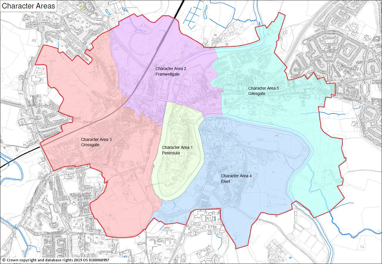
4.46 Durham City Conservation Area (see Maps 3 and 4) includes the Peninsula with the Cathedral and Castle as its centrepiece, the Market Place and medieval streets leading from Silver Street to the west, Claypath to the north-east, Elvet to the east and the slightly more distant medieval suburb of Gilesgate. The natural ‘bowl’ in which the City is located, topography, the importance of green wedges of countryside and other significant green areas contribute significantly to, and enhance, the setting of the historic townscape of the City as a whole. The conservation area is widely recognised as being of outstanding importance. Specific districts within the Conservation Area have been identified, each with a distinctive character. The Character Areas in the Durham City Conservation Area which fall in Our Neighbourhood are: Peninsula Area, Framwellgate Area, Crossgate Area, Elvet Area and Gilesgate Area.
4.47 The Burn Hall Conservation Area (see Map 3) includes the country estate of Burn Hall (listed grade II*) with a complex of late eighteenth and early nineteenth century buildings, which stand in a site of 72 hectares. The estate is situated three miles south of Durham City in a rural area, adjacent to the west side of the A167 road, and is enclosed to the north, west and south by the River Browney. The Hall faces south with land falling away and offering views of the river. The principal building is a two storey sandstone Hall designed by Ignatius Bonomi (with an impressive porte-cochere entrance). In the grounds are a nineteenth century wooden conservatory (listed grade II) and a stone ice house (listed grade II). In the park the Home Farm complex includes a stone Cow House and brick Bull House (late eighteenth century listed grade II*). Nearer the Hall, the walled kitchen garden and estate cottages, now converted into offices, date from the late eighteenth century (listed grade II). The grounds are a Grade II registered park and garden.
4.48 Applicants need to convincingly demonstrate their understanding of the development site’s context and how it has influenced their design. Quality of design is important but it does not have to be conservative.
Justification
4.49 Conservation Areas are places where buildings and spaces around them interact to form distinctive visible areas of quality and “special architectural or historic interest, the character or appearance of which it is desirable to preserve or enhance” (PPG ‘Conserving and enhancing the historic environment’ para. 023).
4.50 The City of Durham is one of the most important historic cities in Britain. The quality and architectural coherence of the buildings, combining medieval elements with Georgian and Victorian later interventions, contributes to the historic environment. A medieval network of streets and alleyways (vennels), centred on the Peninsula and radiating outwards, with dramatic topography and extensive green spaces make the Durham City Conservation Area exceptional. The City’s unique townscape forms the immediate setting of the World Heritage Site, its streets and domestic scale emphasising the World Heritage Site’s dominance.
4.51 Durham City was designated as a conservation area in August 1968 focusing on the peninsula, and the area covered was significantly enlarged in 1980 to incorporate a much larger section of the City centre. The Durham City Conservation Area was reviewed in 2015, with some boundary changes, and a character appraisal document produced and formally approved on 29th July 2016. A management proposals section is included in the individual Character Area documents (Durham County Council, 2016b) and development must be in compliance with these. However, the management plan for the Durham City Conservation Area has not yet been published.
4.52 The significance of Durham’s historic environment is recognised and cherished by experts and local people, who responded to the Durham City Conservation Area appraisal consultation and appreciate that national heritage is a significant economic and social resource. These responses are summarised in the individual Character Area appraisal documents (Durham County Council, 2016b). The intense public interest in sustaining and enhancing the distinctive character of the individual areas within the Durham City Conservation Area indicates the need to ensure that the area’s heritage significance and sense of place are given appropriate weight in planning decisions. Proposals for change should be considered in the context of the impact on the heritage significance of the assets affected and their setting. Applicants need to convincingly demonstrate their understanding of the site’s context and how it has influenced the design of their proposal. The importance of participation and enjoyment of the historic environment for present and future generations must be supported by development that is of high quality in both design and execution and has a durable quality: aspiration for imaginative and well designed buildings is strongly recommended by Historic England (2008, para.138).
4.53 A review of the Durham City Conservation Area was undertaken in 2015 and a character appraisal document was produced and formally approved on 29th July 2016 (Durham County Council, 2016b). The Conservation Area is divided into five Character Areas, each with their own character appraisal, based on the Peninsula and the four adjacent historical Boroughs which have changed little: Framwellgate, Crossgate, Elvet and Gilesgate. Detailed surveys of the character areas indicate that they make a significant contribution to the Conservation Area and support the Peninsula area while having their own diverse and significant individual identities. It is essential that planning decisions support and enhance the character areas while recognising their individual contribution to the Conservation Area. A more detailed description of these character areas is given in Appendix A. They comprise:
- The Peninsula lies within the natural defence afforded by the River Wear. It has evolved from a fortified citadel with Cathedral and Castle, dominating the Market Place and town at the lower northern end, to a romantic landscape with ornamental gardens. The medieval street layout with key pilgrimage routes has remained largely unaltered.
- Framwellgate which lies to the North and North-West of the City is of historical importance and developed from The Bishop’s Borough. It includes the medieval church of St Margaret’s and the left bank of the River Wear where stood the Bishop’s Mill. From this area there was access to the City by the Clayport Gate.
- Crossgate is the main route to the City from the West. The present residential areas are the result of development in the nineteenth century with robust terraces of well-built brick houses. This area also contains the prized green areas of Flass Vale and Observatory Hill.
- Elvet lies to the South of the City and along the left bank of the River Wear. It contains part of the river’s flood plain and provides an important transition between open countryside and the urban environment. The area has the impressive backdrop of the Cathedral and Castle with many outstanding views.
- Gilesgate forms the North-Eastern boundary of the Conservation Area and is situated on the right bank of the River Wear before it enters the gorge which surrounds the peninsula. The street plans have been altered to accommodate the A690 but there are many localities which keep their earlier appearance.
Next section: Policy H3: The Character Areas