
Policy G3: Creation of the Emerald Network
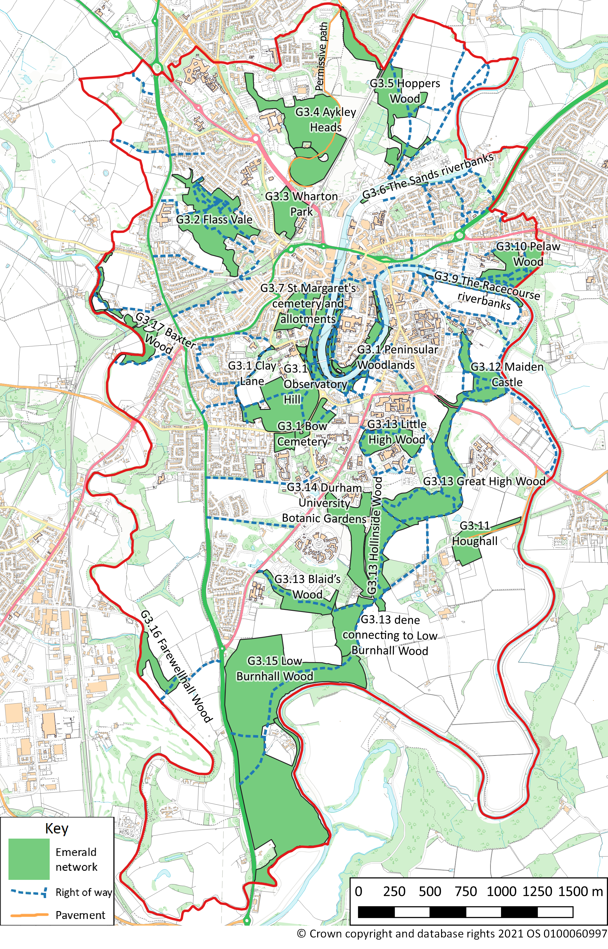
An Emerald Network is identified, as shown on Proposals Map 3, which comprises sites of wildlife interest within Our Neighbourhood linked by public rights of way or pavements. These sites are:
- Observatory Hill; and
- Flass Vale; and
- Wharton Park; and
- Aykley Heads; and
- Hoppers Wood; and
- The Sands riverbanks; and
- St Margaret’s cemetery and allotments; and
- Peninsular Woodlands; and
- The Racecourse riverbanks; and
- Pelaw Wood (the part that lies in Our Neighbourhood); and
- Houghall; and
- Maiden Castle; and
- Hollinside Wood, Great High Wood, Little High Wood, Blaid’s Wood, dene connecting to Low Burnhall Wood; and
- Durham University Botanic Gardens; and
- Low Burnhall Wood; and
- Farewellhall Wood (the part that lies in Our Neighbourhood); and
- Baxter Wood (the part that lies in Our Neighbourhood).
Proposals for the purpose of improving the biodiversity of sites in the Emerald Network will be supported.
Proposals for the purpose of improving the amenity of sites in the Emerald Network, or for improving existing footpaths within or between these sites, or providing additional footpaths within or between these sites, particularly for improving accessibility for people with a disability, will be supported as long as they cause no significant harm to the biodiversity of these sites.
4.109 The Emerald Network comprises designated wildlife sites (such as Local Nature Reserves, Local Wildlife Sites, and Ancient Woodland Sites), key green sites (such as parks and gardens), and the River Wear and the riverbanks. The sites are connected by public rights of way or pavements. In some cases the existing PROW or pavement may skirt the site rather than provide access into the site. Other Local Wildlife sites in Our Neighbourhood have not been included in the Emerald Network as they are not accessible by public rights of way or pavements, e.g. Moorhouse Wood and Borehole Wood. The Emerald Network includes the only sites that meet the above criteria in Our Neighbourhood (see the assessment of open spaces in Our Neighbourhood undertaken for this Neighbourhood Plan – Durham City Neighbourhood Planning Forum, 2018). This policy does not provide public access to these sites if such access is currently restricted by the site owners. Any provision of public access to a site is at the discretion of the owner. The Emerald Network is only part of the green infrastructure within Our Neighbourhood. The Emerald Network also links to a number of sites of wildlife interest that lie immediately adjacent to Our Neighbourhood. These comprise: part of Baxter Wood, part of Farewellhall Wood, Old Durham Gardens, part of Pelaw Wood, Frankland Wood and Kepier Wood.
4.110 The purpose of the Emerald Network is to encourage people (residents, visitors and tourists) to visit key wildlife sites in Our Neighbourhood for the leisure and health benefits they provide. The ‘Looking Forwards’ initiative 6 outlines how the Emerald Network could be set up.
Justification
4.111 The idea for an Emerald Network developed from discussion between the Forum and the Friends of Flass Vale (comprising a membership of 250 people). It builds on policy R13 ‘River Wear Walkway’ from the City of Durham Local Plan saved policies and incorporates policies E5, E26 and T21. Policy R13 was developed by the Council into the idea of a Necklace Park but this idea was never implemented.
4.112 The benefits of the Emerald Network include:
- improving the image of the City by proving an extra tourist attraction
- providing a leisure asset for local people, and thus improving their well being
- counteracting the fragmentation of wildlife habitat within the City: fragmentation has been shown to reduce plant and animals populations to levels where they risk becoming extinct
- promoting and improving access rights and the Public Rights of Way network through the City
- maintaining links with the wider countryside and seeking to improve wildlife corridors to designated sites such as the Deerness Valley, Bearpark and Croxdale Woods and Brasside/Low Newton wetlands.
4.113 The Emerald Network would complement other trails being set up by Durham County Council or other organisations.
Proposals Map 3: Emerald Network
An interactive version of this map is available at http://maps.durhamcity.org.uk/npf/Proposals_Map_3.php
Next section: Policy G4: Enhancing the Beneficial Use of the Green Belt