
Policy G3: Creation of the Emerald Network
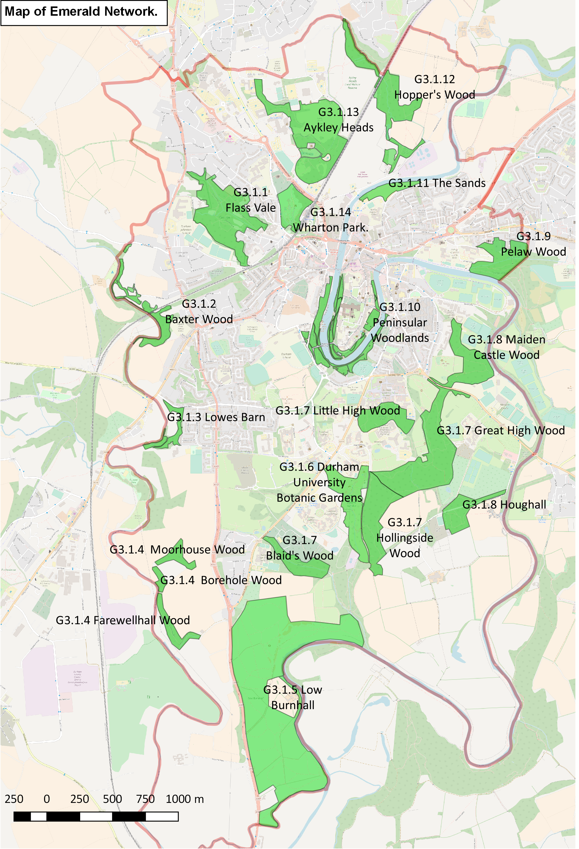
G3.1: An Emerald Network is designated which comprises sites of wildlife interest within Our Neighbourhood linked by public footpaths. These sites comprise designated wildlife sites, such as Local Nature Reserves, Local Wildlife Sites, Ancient Woodland Sites, key green sites, such as parks and gardens, and the River Wear and the riverbanks. The sites included in the Emerald Network are:
- Flass Vale; and
- Baxter Wood (the part that lies in Our Neighbourhood); and
- Lowesbarn; and
- Moorhouse Wood, Borehole Wood, Farewellhall Wood (the part that lies in Our Neighbourhood); and
- Low Burnhall; and
- Durham University Botanic Gardens; and
- Hollingside Wood, Great High Wood, Little High Wood, Blaid’s Wood; and
- Houghall/Maiden Castle; and
- Pelaw Wood (the part that lies in Our Neighbourhood); and
- Peninsular Woodlands; and
- The Sands; and,
- Hoppers Wood; and
- Aykley Heads; and
- Wharton Park.
G3.2: Development proposals to improve the biodiversity and / or amenity of sites or footpaths in the Emerald Network will be supported. Proposals that would result in a deterioration in the wildlife value of a site in the Network will be refused.
4.83 The Emerald Network sites are shown on Map 7. Some of these sites have designations (see Table E1 in Appendix E). The Emerald Network also links to a number of sites of wildlife interest that lie immediately adjacent to Our Neighbourhood. These comprise: part of Baxter Wood, part of Farewellhall Wood, Old Durham Gardens, part of Pelaw Wood, Frankland Wood and Kepier Wood. The sites are connected by public footpaths. Durham County Council provides a ‘Definitive Public Rights of Way’ map online. Other Local Wildlife sites in Our Neighbourhood have not been included in the Emerald Network as they are not accessible by public footpaths. Policy Implementation Project 1 in Chapter 5 indicates how this policy could be taken forward.
Justification
4.84 The idea for an Emerald Network developed from discussion between the Forum and the Friends of Flass Vale (comprising a membership of 250 people). It builds on policy R13 ‘River Wear Walkway’ from the City of Durham City Local Plan saved policies and incorporates policies E5, E26 and T21(City of Durham Council, 2004; Durham County Council, 2015a). Policy R13 was developed by the Council into the idea of a Necklace Park but this idea was never implemented.
4.85 The Emerald Network will create a network of sites having wildlife interest lying within or adjacent to Our Neighbourhood. Existing rights of way will be used to develop corridors between the sites so as to enhance biodiversity and connectivity between them. The benefits of the Emerald Network include:
- improving the image of the City by proving an extra tourist attraction
- providing a leisure asset for local people, and thus improving their wellbeing
- counteracting the fragmentation of wildlife habitat within the City: fragmentation has been shown to reduce plant and animals populations to levels where they risk becoming extinct
- promoting and improving access rights and the Public Rights of Way network through the City
- maintaining links with the wider countryside and seeking to improve wildlife corridors to designated sites such as the Deerness Valley, Bearpark and Croxdale Woods and Brasside/Low Newton wetlands.

Map 7: Map of Emerald Network. The boundary of Our Neighbourhood is indicated and shows which sites are in the Network and which adjacent sites the Network links to.
Here is a zoomable map of the Emerald Network.
Next section: Policy G4: Enhancing the Beneficial Use of the Green Belt
6 Responses to Policy G3 2017