
Policy G4: Enhancing the Beneficial Use of the Green Belt
Proposals within the Green Belt land in the Sidegate and Frankland Lane area of Our Neighbourhood as shown in Proposals Map 4 for the purpose of improving access (particularly for people with disabilities), green corridors, landscape, or biodiversity, or for enhancing visual amenity, will be encouraged and supported where such proposals:
- sustain, conserve and enhance the inner bowl setting of the World Heritage Site, and the Durham City Conservation Area; and
- do not cause significant harm to the overall quality of the Green Belt environment, particularly its openness.
Proposals within the Green Belt land in the area of Our Neighbourhood West of the A167 from Browney Bridge to Neville’s Cross fas shown in Proposals Map 4 or the purpose of improving access (particularly for people with disabilities), green corridors, landscape, or biodiversity, or for enhancing visual amenity,will be encouraged and supported, where such proposals:
- sustain, conserve and enhance the outer bowl of the World Heritage Site; and
- do not cause significant harm to the overall quality of the Green Belt environment, particularly its openness.
Proposals Map 4: Green Belt – areas for improvement
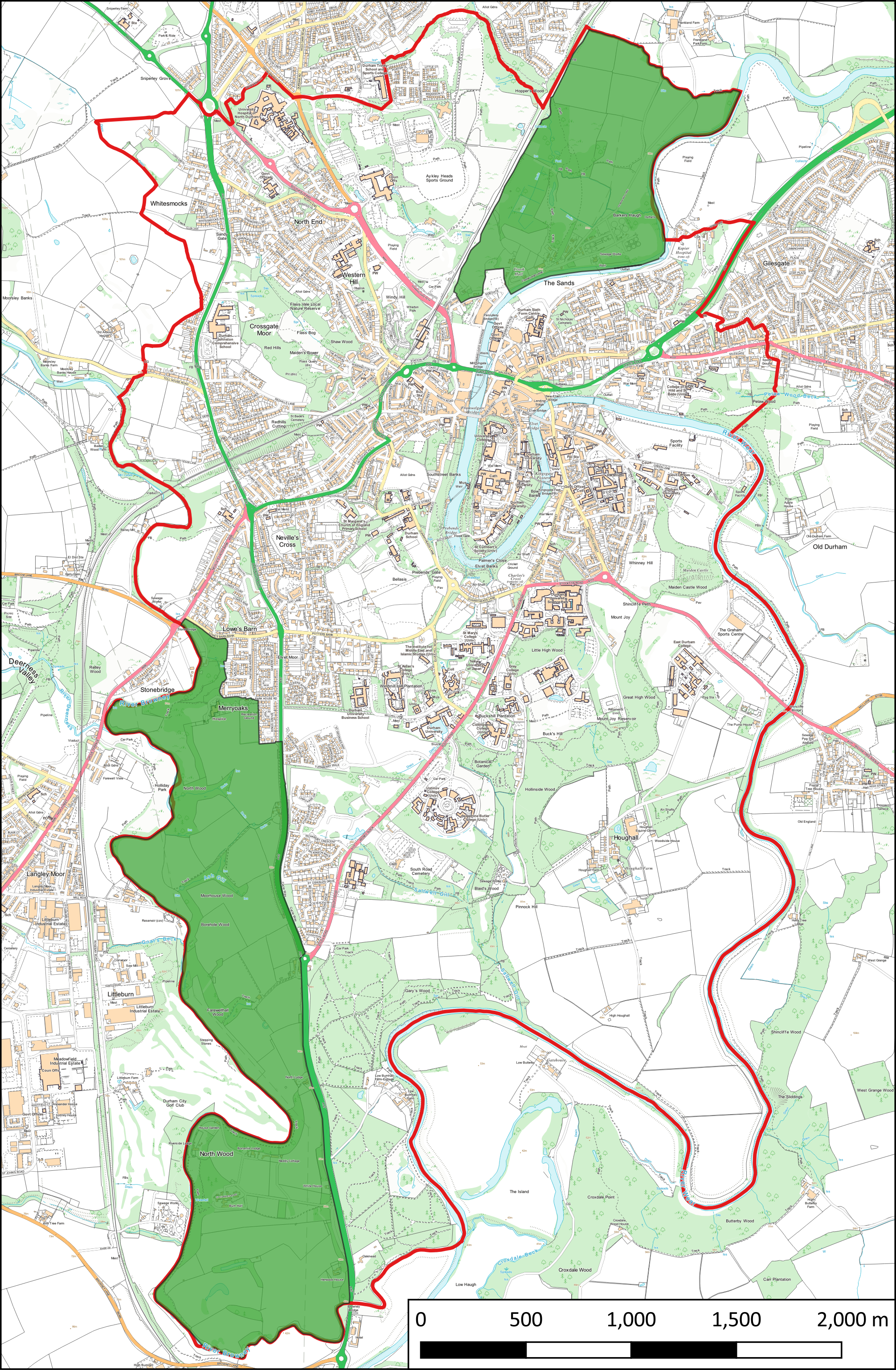
An interactive version of this map is available at http://maps.durhamcity.org.uk/npf/Proposals_Map_4.php
Justification
4.114 The NPPF (Chapter 13) attaches great importance to the Green Belt and to its protection from development. Local people, as shown by responses to the Forum’s priority survey (Durham City Neighbourhood Planning Forum, 2015) and by the existence of community bodies such as ‘The Friends of Durham Green Belt’, place great value on the Green Belt within Our Neighbourhood. The Green Belt is particularly important to Our Neighbourhood because of one of its purposes “to preserve the setting and special character of historic towns” (NPPF para. 134). Saved policies of the City of Durham Local Plan are relevant to the Green Belt (E1).
4.115 There is the opportunity to enhance the Green Belt. The NPPF (para. 141) states that: “Once Green Belts have been defined, local planning authorities should plan positively to enhance the beneficial use of the Green Belt, such as looking for opportunities to provide access; to provide opportunities for outdoor sport and recreation; to retain and enhance landscapes, visual amenity and biodiversity; or to improve damaged and derelict land.”
4.116 The areas of Green Belt within Our Neighbourhood are shown in Map 5. They comprise land at: Aykley Heads, Franklands, Sidegate, Kepier, The Sands, Pelaw Wood, Riverbanks, Racecourse, Whinney Hill, Maiden Castle, Mountjoy, Houghall, Great High Wood, Little High Wood, Hollinside Wood, Howlands, Blaids Wood, Low Burnhall, West of the A167 to the River Browney (covering Burnhall, Merryoaks, Lowesbarn), West of the Nevilles Cross Bank and West of the A167 (covering Nevilles Cross, Quarry House Farm and Whitesmocks), Plass Vale.
4.117 Most of this land is covered by policies in this theme that aim to provide further protection and enhancement; generally by Policy G1, and specifically:
- As Local Green Spaces (Policy G2): the River Wear corridor comprising that in the areas of The Sands and the Racecourse; the DLI grounds area at Aykley Heads; woodland on the south side of the City comprising Maiden Castle, Great High Wood, Hollinside Wood, Blaids Wood; West of the Nevilles Cross Bank and West of the A167 (covering Nevilles Cross, Quarry House Farm, Crossgate and Whitesmocks, i.e. the Nevilles Cross Battlefield site).
- As sites within the Emerald Network (Policy G3): Flass Vale; Aykley Heads; Franklands, i.e. the accessible part of Hopper Wood; The Sands riverbanks; Racecourse riverbanks; Pelaw Wood; Maiden Castle; Houghall; Great High Wood, Little High Wood, Hollinside Wood, Blaids Wood; Low Burnhall, i.e. Low Burnhall Wood; West of the A167 to the River Browney, i.e. Farewellhall Wood; West of the Nevilles Cross Bank and West of the A167 (covering Nevilles Cross, Quarry House Farm, Crossgate and Whitesmocks, i.e. Baxter Wood).
4.118 This leaves Green Belt land at Sidegate and Franklands Lane and West of the A167 from Browney Bridge to Nevilles Cross not covered by additional policies in this neighbourhood plan.
Map 5: Green Belt in Our Neighbourhood
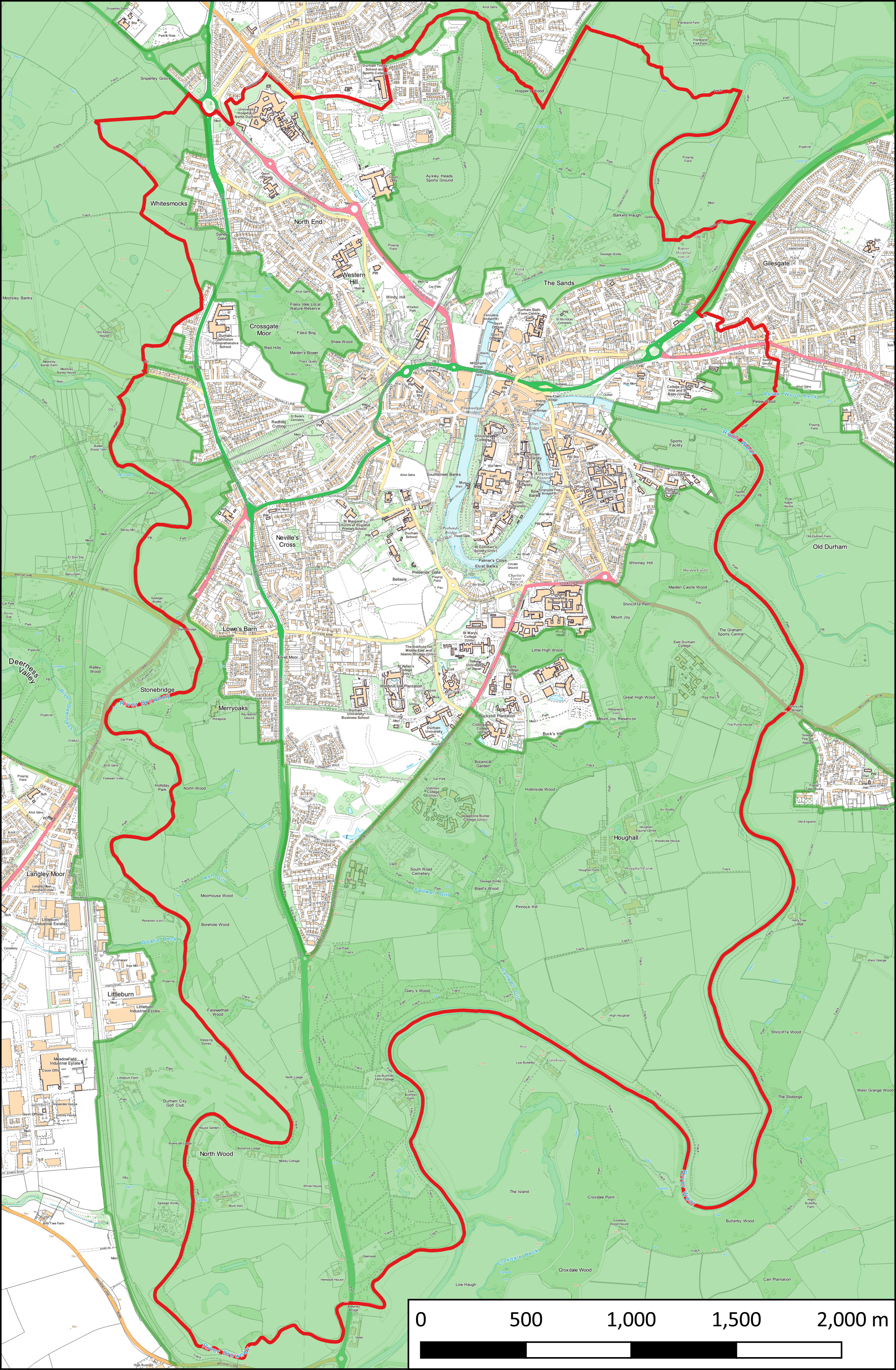 An interactive version of this map is available at http://maps.durhamcity.org.uk/npf/Map_5.php
4.119 Green Belt land at Sidegate and Franklands Lane lies in the Durham City Conservation Area and the inner bowl of the World Heritage Site. It is important that views within the inner bowl to and from the World Heritage Site are protected (Durham World Heritage Site, 2017, p.74). This is covered by Policy H1 in this Plan. Additionally this land would benefit from improved access, particularly for people with disabilities, and improvement to the wildlife value and visual amenity of the land and the green assets upon it.
4.120 The Green Belt land West of the A167 from Browney Bridge to Nevilles Cross is mostly agricultural land. It lies within the outer bowl of the World Heritage Site. It is important that any developments in the outer bowl
within Our Neighbourhood do not have a negative impact on the setting of the World Heritage Site (Durham World Heritage Site, 2017, p.19). This is covered by Policy H1 in this Plan. The wooded and wildlife value areas could have improved access as most are not accessible by public rights of way.
Next section: Theme 3: A City with a diverse and resilient economy