
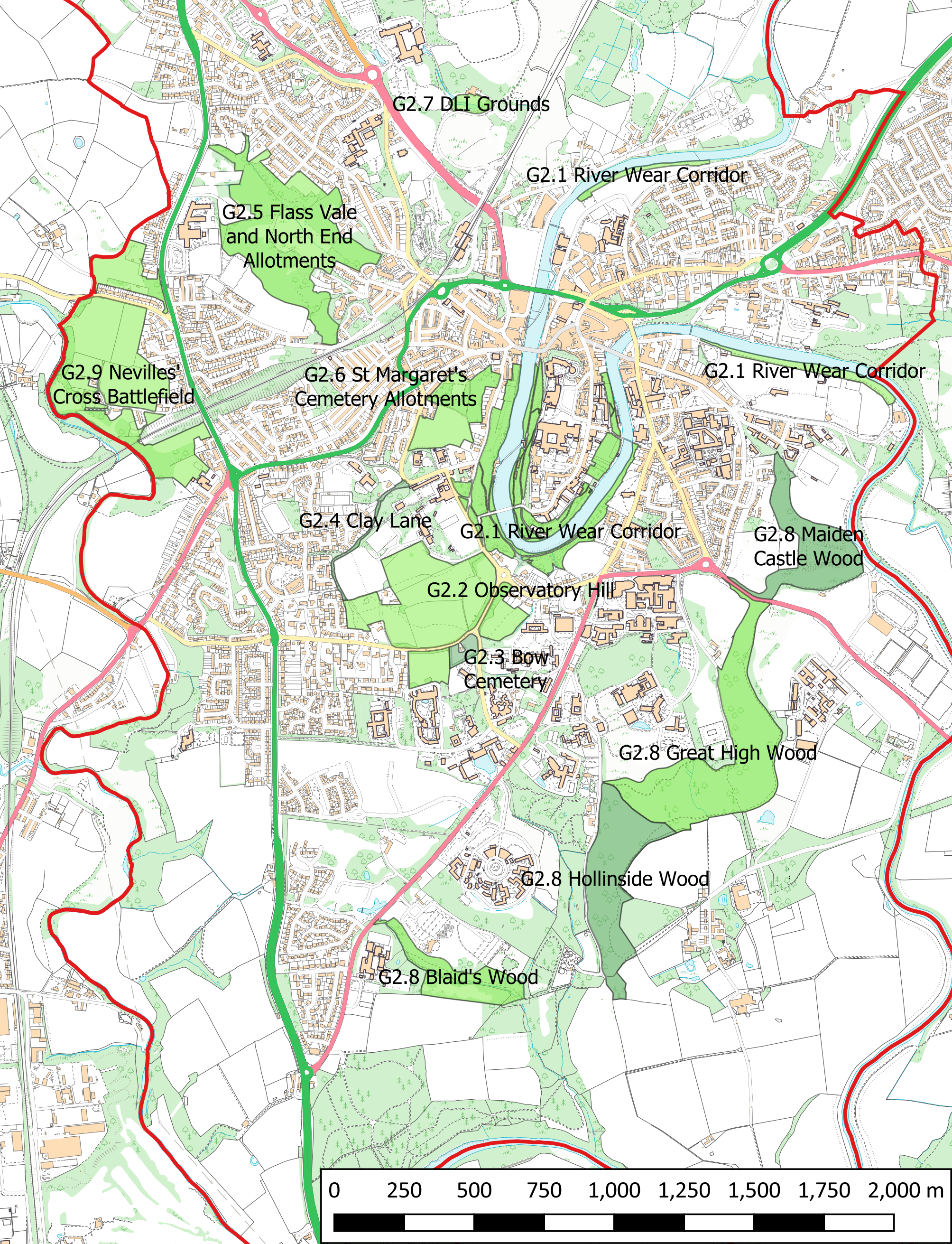
Policy G2: Designation of Local Green Spaces
The following areas (shown on Proposals Map 2) are designated as Local Green Space where inappropriate development should not be approved except in very special circumstances:
- The River Wear corridor in the areas of the Peninsular Woodlands, the Racecourse and the Sands
- Observatory Hill
- Bow Cemetery
- Clay Lane
- Flass Vale and North End allotments
- St Margaret’s Cemetery and allotments
- Durham Light Infantry (DLI) grounds
- Maiden Castle Wood, Great High Wood, Hollinside Wood, and Blaid’s Wood
- Neville’s Cross Battlefield
4.102 An assessment of open spaces in Our Neighbourhood has been undertaken for this Neighbourhood Plan (Durham City Neighbourhood Planning Forum, 2018) As a result of that assessment, the areas in the policy above (see Proposals Map 2) have been designated as Local Green Spaces for the following reasons:
- G2.1: The River Wear Corridor in the areas of the Peninsular Woodlands, the Racecourse and the Sands:
The river and river corridor of the River Wear as it meanders through the City’s floodplain and cuts through the rocky gorge of the peninsular is the most significant landscape feature of the City. Its important contribution to the setting of the World Heritage Site and the City cannot be overestimated. The river and riverbanks are an important component of the Durham City Conservation Area in all five character areas. Respondents to the Forum’s priority survey listed the riverbank setting and riverside walks as the second highest attribute of what is good about Durham City. The river paths are well used for walking and leisure activities, and provide an important wildlife corridor linking the character areas of the City Conservation Area to each other and to the wider countryside within Our Neighbourhood. Protection of the river corridor was included in the City of Durham Local Plan saved policy E5 on protecting open spaces within Durham City, and a River Wear Walkway was proposed in policy R13. A draft development and management strategy for the riverbanks has been drawn up for Durham County Council with the aim of revitalising the riverbanks. The current report (Blue Sails Consulting Ltd, 2017) focuses on the Peninsular Riverbanks. Later work will look at the wider riverbanks. The particular sections of the riverbanks within the City centre comprising this Local Green Space are in the areas of: (i) the Peninsular riverbanks, (ii) the Racecourse, and (iii) the Sands. The Peninsular riverbanks are a key part of the green setting of the World Heritage Site, providing iconic views to and from the Cathedral and Castle. They are of historic value, with historic riverbank gardens and walks, forming part of an 18th century designed landscape. They have high community value as a walking area and a location for events, e.g. Lumiere. They are a key tourist attraction, accessible by public rights of way. The riverbanks in the Racecourse vicinity provide a popular walking route. They provide iconic views to World Heritage Site, as well as views of the river and surrounding areas of the City, and of events held on the Racecourse and the river. The Racecourse has high community value as a site for a range of sporting venues. It is a site for events, particularly the historic and iconic Durham Miners Gala and the Durham Regatta. The riverbanks also provide access beside, and into, Pelaw Woods. The riverbanks in the vicinity of the Sands provide a popular walking route, with views of the surrounding areas of the City and of the Green Belt in the Frankland Lane area. They provide access to the Sands. The Sands have historic value as one of the few areas of common land left in Our Neighbourhood. It is a grassed area with recreational value and providing a venue for events, e.g. the annual Easter Fair. The rest of the riverbanks in Our Neighbourhood are protected by Policy G1 which seeks to retain existing, and support new, footpaths, green corridors, dark corridors and cycle paths along the river where the physical space allows.
- G2.2: Observatory Hill:
The Observatory Hill Local Green Space comprises Observatory Hill and two fields on the other side of Potters Bank. Observatory Hill, adjoining Potters Bank and near to Durham School, is within both the inner bowl of the World Heritage Site and the Durham City Conservation Area. Its elevated site makes it very visible from the centre, and it contributes to the green and rural landscape setting for the World Heritage site and the City Centre. It is well used by local people, and has been for countless years, for access for walking, dog walking, exercise, sitting, picnics, sledging in winter, photography, etc – all the types of purposes for which open green space is used. There are footpaths criss crossing the area (though not all are PROW). Most of Observatory Hill is used for agricultural purposes, as rough grassland. Land around the Observatory contained orchids and other rare plants. However, these have been lost since Durham University’s tenant has ploughed the land to claim the agricultural subsidy. However, it would be possible to recreate the plant community if the land were managed with conservation in mind. At the east side of Observatory Hill the Cathedral has a playing field, with a small section of this at the entrance used for parking. This playing field is screened by mature trees and hedgerows. Observatory Hill provides important views towards and from the World Heritage Site, and if developed would blight the views in that direction from the World Heritage Site as the Hill is so high, and mitigation by masking by trees would not be effective or feasible. Observatory Hill has City-wide esteem, with iconic status for a thousand years and more. It was included in the City of Durham Local Plan saved policy E5 on protecting open spaces within Durham City. Two adjacent fields (one at the bottom of Potters Bank North West of St Mary’s College, which is partly within the Durham City Conservation Area, and one falling down from Elvet Hill / St Aidan’s College South of Potters Bank) provide one of the key ‘green fingers/wedges’ that are an important characteristic of Durham City, leading towards the World Heritage Site. In the Forum’s priority survey respondents had high regard for the ‘woodland’ wedges bringing green space into the City. The two fields provide rough grassland and are used for agricultural purposes. The field falling down from St Aidan’s College provides an iconic view of the World Heritage Site, and development in its upper levels would damage views to and from the World Heritage Site. The two fields form part of the Mount Oswald-Elvet Hill Parkland Landscape Area designated in saved policy E5.2 of the City of Durham Local Plan.
- G2.3: Bow Cemetery:
Bow Cemetery provides a beautiful wildlife feature adjacent to Bow Cottage, a Grade II listed building which was the old Cemetery lodge. Bow Cemetery is still occasionally used for burials. The remains of Scottish soldiers, who were imprisoned and died in Durham following the Battle of Dunbar in 1650, were laid to rest here in 2018.
- G2,4: Clay Lane:
Clay Lane (a PROW – FP15) has been an important pedestrian route into Durham since the medieval period and continues to serve as a major pedestrian artery into the City centre. It is an attractive green area of biodiversity, providing a significant habitat for wildlife that includes badgers, foxes, bats and the occasional weasel. It forms one of the green corridors linking the river banks with countryside outside the City. It is unlit and therefore provides an important dark corridor.
- G2.5: Flass Vale and North End allotments:
Flass Vale is an historic area of woodland lying within the Green belt and the Crossgate Character Area of the Durham City Conservation Area. Its wildlife value has been recognised by designation as a Local Wildlife Site; part of the site is registered as Common Land and part is designated as a Local Nature Reserve. Maiden’s Bower, a Bronze Age round cairn and scheduled ancient monument, is located in Flass Vale. Local legend says Maiden’s Bower was the site of a vigil held during the Battle of Neville’s Cross. The North End allotments and leisure gardens that lie to the North East of the site are an integral part of this Local Green space. Such a central site is always under threat of development, and new permitted developments have ‘nibbled away’ at the edges of this site. The local importance of this site is demonstrated by the active group the ‘Friends of Flass Vale’ who manage and care for the site.
- G2.6: St Margaret’s Cemetery and allotments
These lie between Crossgate and South St and provide an important green space in the Centre of the City, and within the Crossgate Character Area of the Durham City Conservation Area. The Cemetery provides a wildlife refuge, a place for walking and quiet contemplation as well as being of historic value (St Margaret’s Church is one of the earliest churches in the City, dating from the 12 century). The Cemetery abuts onto the allotments. The allotments provide for gardening and leisure, as well as a wildlife resource, and are of historic value (the site has been cultivated since the middle ages, and was once the Cathedral’s vegetable garden and fish ponds; it is thought that the old quarry in the allotments was the source of the stone used to build the Cathedral). This area was included in the City of Durham Local Plan saved policy E5 on protecting open spaces within Durham City.
- G2.7: Durham Light Infantry (DLI) grounds:
The DLI grounds are within the Green Belt. They have wildlife and recreational value, with areas of the site providing views of the City Centre. The significance of these grounds as a resting place for the ashes of members of the DLI Regiment makes this a site of huge importance and value to local people. Part of these grounds could be made into a Memorial Garden. The DLI grounds could function in association with the refurbished Wharton Park by providing a safe and secure picnic area, particularly for parents and children: the current DLI car park providing necessary car parking for people using these grounds and facilities.
- G2.8: Maiden Castle Wood, Great High Wood, Hollinside Wood and Blaid’s Wood:
These woods have been in existence since at least the 19th Century, though replanting has occurred in the 20th Century. Parts of these woods show the remnants of old railway embankments, and interpretation boards in Great High Wood give visitors information about the railway and mining historical background. Maiden Castle is an Iron Age promontory fort and is listed as a Scheduled Ancient Monument. Hollinside Wood, Great High Wood and Blaid’s Wood are designated as Areas of High Landscape Value, Ancient Semi-Natural Woodland, Sites of Nature Conservation Importance and Sites of Ecological Value. They lie within the Green Belt. All these woods provide a near continuous block of woodland with public access. They are used by the public for walking, cycling and leisure activities. The woods are renowned for their display of English bluebells in the Spring. As Durham University says: “The number of designations covering the woodlands reflect their importance in terms of landscape, amenity, and conservation.” (Durham University. Biodiversity Policy)
- G2.9: Nevilles Cross Battlefield:
This Local Green Space comprises the undeveloped area of the registered battlefield site within Our Neighbourhood, including land lying on both sides of the registered public footpaths forming part of a boundary walk around the edge of the Battlefield site to the immediate west of Crossgate Moor. This area lies within the Green Belt. The battlefield is of national significance. The battle of Neville’s Cross, between Scottish and English forces, took place on 17th October 1346, on moorland just to the west of Durham. This was a significant battle as the Scots were comprehensively defeated, and this loss led to English occupation of parts of Scotland south of the Forth and Clyde rivers. It was over a century before the Scots could recover this land. The battlefield where the armies assembled before the battle is largely undeveloped. The remains of a Cross commemorating the battle is sited in the built-up area of Nevilles Cross and is a scheduled ancient monument. The battlefield is registered in the Register of Historic Battlefields (UK Battlefields Resource Centre, no date). A copy of the map is available to view at http://www.battlefieldstrust.com/media/401%2Epdf (accessed September 2019)
4.103 It should be noted that the Neighbourhood Plan can only cover areas that are within its boundary. One of the Local Green Spaces – Neville’s Cross Battlefield – also crosses over into the neighbouring parish of Bearpark. Future co-operation with the neighbourhood plan in this parish could hopefully result in the whole of this important area becoming a Local Green Space.
4.104 The NPPF (para. 99 to 101) provides for neighbourhood plans to designate Local Green Spaces allowing “communities to identify and protect green areas of particular importance to them” (PPG para. ‘Open space, sports and recreation facilities, public rights of way and local green space’ 005 to 021). “Whether to designate land is a matter for local discretion. For example, green areas could include land where sports pavilions, boating lakes or structures such as war memorials are located, allotments, or urban spaces that provide a tranquil oasis.” (para. 013) “However, other land could be considered for designation even if there is no public access (e.g. green areas which are valued because of their wildlife, historic significance and/or beauty). Designation does not in itself confer any rights of public access over what exists at present. Any additional access would be a matter for separate negotiation with land owners, whose legal rights must be respected.” (para. 017) “Designating a green area as Local Green Space would give it protection consistent with that in respect of Green Belt, but otherwise there are no new restrictions or obligations on landowners.” (para.020). Therefore the existing public access status and operational use of the designated Local Green Spaces can continue as usual.
4.105 Policies for managing development in a Local Green Space should be consistent with those for Green Belts (NPPF para. 101) Therefore, inappropriate development, harmful to the characteristics that make the Local Green Space special, would not be approved except in very special circumstances (NPPF para. 143). However, there are exceptions for some types of new building (NPPF para. 145) e.g. “buildings for agriculture … the provision of appropriate facilities … for outdoor sport, outdoor recreation, cemeteries … and allotments, ; as long as the facilities preserve the openness of the Green Belt [Local Green Space] and do not conflict with the purposes of including land within it; the extension or alteration of a building provided that it does not result in disproportionate additions over and above the size of the original building; … the replacement of a building, provided the new building is in the same use and not materially larger than the one it replaces”. Additionally, some forms of development are also not inappropriate (NPPF para. 146) “provided they preserve its openness and do not conflict with the purposes of including land within it” e.g. “local transport infrastructure which can demonstrate a requirement for a Green Belt [Local Green Space] location; the re-use of buildings provided that the buildings are of permanent and substantial construction; e) material changes in the use of land (such as changes of use for outdoor sport or recreation, or for cemeteries and burial grounds)”.
Proposals Map 2: Local Green Spaces
An interactive version of this map is available at http://maps.durhamcity.org.uk/npf/Proposals_Map_2.php
Justification
4.106 Durham County Council (2019b,c) has identified Areas of Higher Landscape Value. The Areas of Higher Landscape Value within our Neighbourhood comprise: Aykley Heads and Frankland; Durham Riverbanks; Observatory Hill and Elvet Hill; Hollinside, Mountjoy and Whinney Hill; Durham Racecourse and Pelaw; Houghall and Maiden Castle; Houghall Farm; Burn Hall.
4.107 Some of the areas designated here as Local Green Spaces also possess other types of designation, e.g. being within the Green Belt or a conservation area or being a wildlife site or heritage asset. National Planning Practice Guidance states that land that is already protected can be designated as a Local Green Space if there is additional local benefit (PPG ‘Open space, sports and recreation facilities, public rights of way and local green space’ para. 010 and 011). Different types of designation achieve different purposes. The areas listed here are of particular importance to the local community as the reasons given above demonstrate. Additionally, these areas are not as secure as their existing protections would imply. The development pressure in a small constrained area such as Our Neighbourhood is high. There is recent history of planning approvals for large scale developments in the Green Belt with predicted future plans for much more development in the Green Belt. In the Forum’s priority survey (Durham City Neighbourhood Planning Forum, 2015) respondents had high regard for the ‘woodland’ wedges bringing green space into the City, were concerned about loss of / lack of open and green spaces and threat to green belt, and wanted to protect green spaces/green belt and the environment.
4.108 New sites might become available in Our Neighbourhood that might merit designation as Local Green Spaces. This would require amendment of the Neighbourhood Plan. One such site is Mount Oswald. This formed part of an area of open space protected under saved Policy E5.2 of the City of Durham Local Plan. The Mount Oswald site, previously a golf course, was land that had not been built on since the Middle Ages when it was agricultural land. It therefore contains assets of wildlife value including mature trees and a pond containing protected species. The current housing development on this site needs to be placed within the context of a long battle by local residents to retain this green space. The Mount Oswald site is currently being developed to a level greater than provided for in the City of Durham Local Plan. Open spaces retained within that development, including a complex of interconnected parks and open spaces (which retains and adds to the existing green assets) are therefore of particular importance to the local community and likely to warrant designation as a Local Green Space. As areas of open space in this development are being defined through a series of reserved matters applications, it isn’t possible to finalise boundaries at this time. Inclusion, and enhancement, of existing green assets within new developments is the aim of Policy G1. New residential areas might include green areas that were planned as part of the development. Such green areas might be designated as Local Green Space if they are demonstrably special and hold particular local significance. (PPG ‘Open space, sports and recreation facilities, public rights of way and local green space’ para. 012).
Next section: Policy G3: Creation of the Emerald Network