
Policy D1: Land for Residential Development
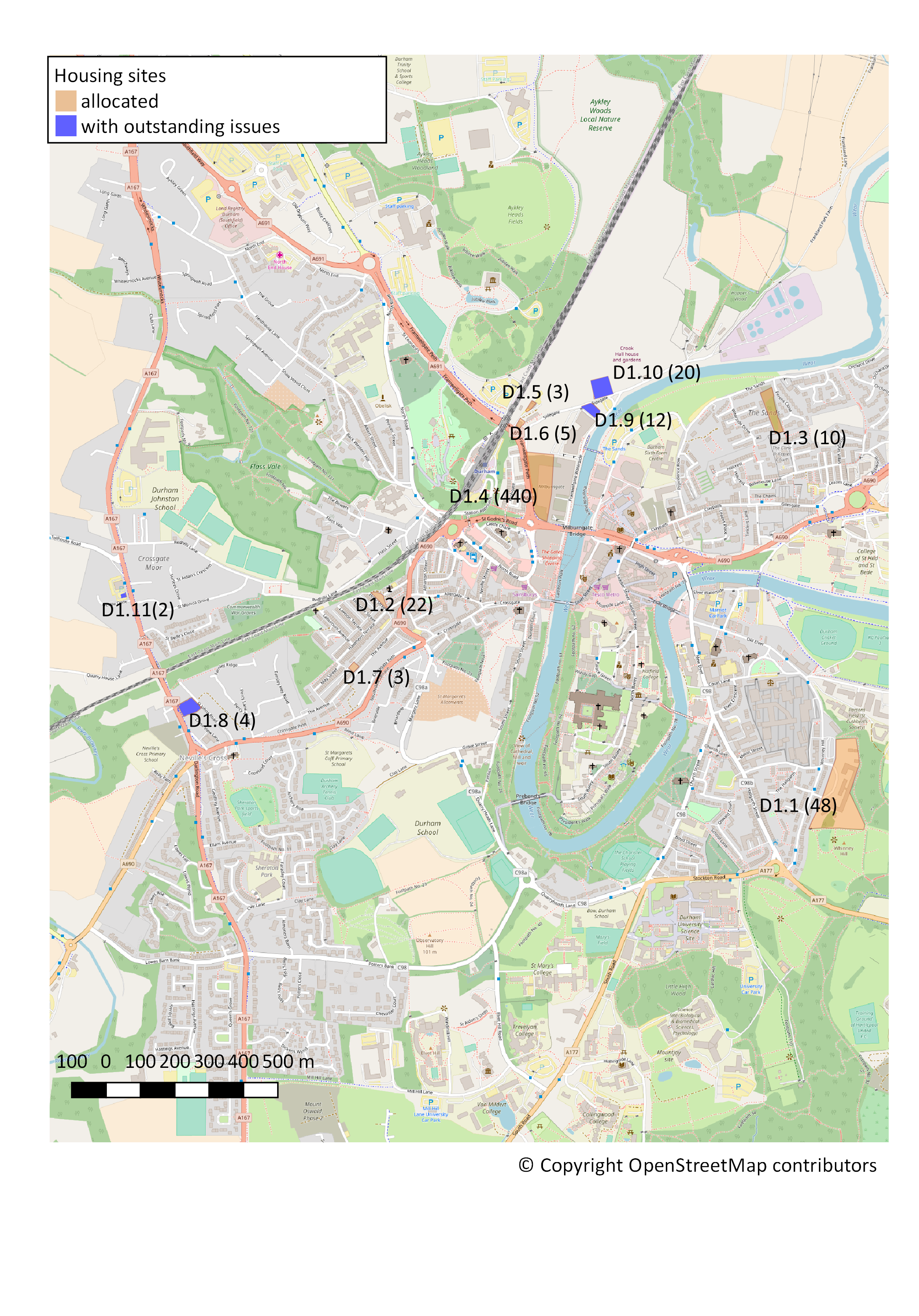
The following sites as shown on the proposals map are allocated for housing development in the quantities indicated:
- Whinney Hill (former Johnston School) (48)
- John Street (22)
- Bernard Gilpin site, The Sands (10)
- Site of Government Offices, Framwellgate Peth (440)
- Offices at Diamond Terrace (3)
- Main Street USA etc. (5)
- The Avenue (3)
Map 10: Map of Housing Sites
Here is a zoomable map of the housing sites.
4.146 The Evidence Base for the withdrawn County Durham Local Plan provided potential sites for residential development as listed in the SHLAA Update (Durham County Council, 2014a). In Policy D1 we endorse these and add other sites that we have identified. The number of housing units given for each site is indicative and numbers can be greater or fewer depending on how proposals are designed to deal with topographical and landscape issues and requirements.
4.147 The following notes provide additional information about the sites (shown on Map 10). The principles to be followed are: (i) target occupants to rebalance the community away from predominantly student accommodation; (ii) include provision for older people wherever feasible; (iii) style to mirror that of existing housing in the local area; and (iv) use high quality design standards. In all cases the sites have been assessed through the Sustainability Appraisal process to ensure that the potential impact on known heritage assets has been identified and appropriate mitigation and/or enhancement measures will be applied in accordance with the Sustainability policies S1 and S2 and the six Heritage policies H1 to H6 of this Plan.
- D1.1 Whinney Hill (former Johnston School) (48): now with planning permission for 75 dwellings but the Plan’s aspiration is to keep and renovate the main school building; need to protect existing footpath and provide a minimum 15m buffer of habitat creation against the ancient woodland. Accordingly, in order to provide for the retention of these features, Policy D1.1 allocates provision for only 48 dwellings. Very suitable for older peoples’ accommodation or for average density two storey family houses consistent with the rest of Whinney Hill.
- D1.2 John Street (22): approved for apartments; a good site for older people or for young professionals/young couples starting out. Also a single terrace house could be sited as an addition to the end of the terrace next to the Spiritualist Church.
- D1.3 Former Bernard Gilpin Society, The Sands (10): although approved for 35 units, it would be better to develop it as a completion of Ferens Close plus houses along the front in existing style as average density 2 storey houses. The very bottom of the site lies in Flood Risk Zone 3 and therefore appropriate infrastructure and design measures will be required. Development proposals for this site should undertake a site-specific flood risk assessment.
- D1.4 Site of Government Offices, Framwellgate Peth (440): planning permission has been given for a mixed-use scheme including apartments. Nevertheless, as by far the largest and most prominent residential development site in Our Neighbourhood, it emerges from the Sustainability Appraisal as an exceptionally sensitive site for which the most rigorous application of Sustainability policies S1 and S2 and the six Heritage policies H1 to H6 required for all detailed development proposals. The location is highly suitable for some older peoples’ accommodation with appropriate accessibility provision. The area for the housing units allocated in Policy D1.4 is located in Flood Risk Zone 1 above the lower parts of the Government Offices development that lie in Flood Risk Zones 2 and 3.
- D1.5 Offices at Diamond Terrace (3): suitable for terraced houses matching Diamond Terrace, provided that rights of way are protected and there is no incursion on to the Green Belt.
- D1.6 Main Street USA etc.: (2 or 5): existing space could provide for 2 terraced houses; if the business premises are included then the space could provide for 5 terraced houses, provided that rights of way and trees and surrounding woodland are protected. The site’s location and visibility make it very sensitive in relation to the paramount consideration of safeguarding the setting of the World Heritage Site when evaluating specific development proposals.
- D1.7 24 a, b and c The Avenue: 3 terraced houses matching The Avenue style.
4.148 In respect of a further four sites shown on Map 10, the intention is to allocate them in the final Plan if the issues identified below can be resolved:
- D1.8 Former Shell Garage, A167 (4): this site is not a formal allocation at this stage because it has not been possible to contact the owner, but the aspiration is to include it as an allocation in the final Plan. Although approved for 8 units, the surrounding house-style indicates that 4 average to low density 2 storey houses would be more suitable, with access via St Johns Road rather than the A167; important to keep trees on the boundary of the site; may be costly to develop to deal with underground fuel storage tank.
- D1.9 Sidegate electricity sub-station (12): this site is not a formal allocation at this stage because it lies within Flood Risk Zones 2 and 3. If this can be mitigated, It would be suitable for terraced houses matching Sidegate; provided that development proposals protect surrounding trees and woodland habitats and carry out a site-specific flood risk assessment.
- D1.10 Council-owned car park, Sidegate (20): this site is not a formal allocation at this stage because the owner does not agree at present. It is suitable for two or three rows of terraced houses; provided that development proposals protect surrounding trees and woodland habitats.
- D1.11 Small site next to Sainsbury supermarket on A167 (formerly Pot and Glass Public House): this site is not a formal allocation at this stage because it has not been possible to contact the owner, but the aspiration is to include it as an allocation in the final Plan. It is suitable for 1 or 2 family houses, average density 2 storey houses; protect mature black poplar tree.
4.149 To maximise the contribution that these and any other sites make towards appropriate residential developments, high densities will be encouraged in areas that are characterised by existing higher densities, provided that adequate green and open space provision is included.
4.150 Gavin Barwell, former Minister for Housing and Planning, Department for Communities and Local Government (in a talk reported by Horti, 2016) has suggested the introduction of a policy to tackle ‘land-banking’ by requiring planning permissions to be implemented or forfeited. If this ‘use it or lose it’ approach become official Guidance it will be applied within Our Neighbourhood.
4.151 In addition to housing sites allocated in our Neighbourhood Plan (521 new dwellings of various kinds, with a further 38 if particular issues can be resolved), it is estimated that an additional 11% of houses would become available from small ‘windfall’ sites. This figure is drawn from the new Issues and Options consultation document for the new County Durham Local Plan (Durham County Council, 2016c, p3, para 3.10). Indeed, any new sites that come forward that have the potential for mixed residential development will be supported in principle subject as always to relevant NPPF, County Durham Local Plan and our Neighbourhood Plan policies.
Next section: Policy D2: Student Accommodation in Houses in Multiple Occupation (HMO)
7 Responses to Policy D1 2017