Policy E4: Primary and Secondary Frontages
E4.1: Within Durham City centre’s primary frontage support will be given to retail development (Class A1 uses) which improve the range of shops.
E4.2: Proposals for changes of use of ground floor premises within the primary frontage to non-A1 uses appropriate to a shopping area (defined as retail, leisure, entertainment, sport and recreation, offices, and arts, culture and tourism) will be supported if it can be demonstrated that the use will add to the vitality and viability of the City centre.
E4.3: Within the secondary frontage and in upper floors of the primary frontage the following uses will be supported: shops (A1), financial and professional services (A2), restaurants and cafes (A3), drinking establishments (A4), hot food takeaways (A5), and other uses appropriate to a town centre (defined as retail, leisure, entertainment, sport and recreation, offices, and arts, culture and tourism).
E4.4: Development proposals should demonstrate that the development:
- would not have an unacceptable impact on residential amenity; and
- would have appropriate access provision; and
- would not harm the character of the historic environment.
4.119 The NPPF glossary defines ‘Main town centre uses’ as retail, leisure, entertainment, sport and recreation, offices, and arts, culture and tourism.
4.120 The extent of the shopping area, where new development may be approved, is expected to remain broadly as it is now. However the need to sustain and enhance Durham City centre means that opportunities to improve its retail provision should be taken when they arise through redevelopment and changes of use.
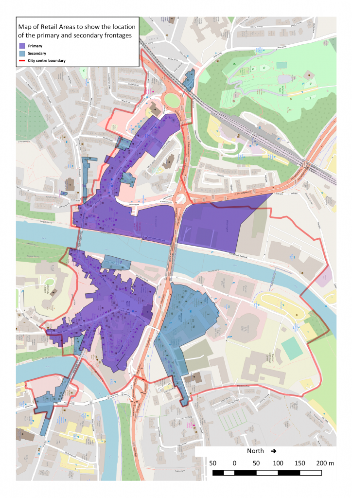
4.121 Map 9 which shows the retail areas, with the primary and secondary frontages, for Durham City has been based on a number of sources: the Retail and Town Centre Uses Study (Durham County Council, 2009b) prepared by GVA Grimley for Durham County Council; the allocations from the Durham City Local Plan (City of Durham Council, 2004); and an aspiration to improve the area of North Road, which was highlighted in the Forum’s priority survey (Durham City Neighbourhood Planning Forum, 2015). It includes the historic core around the market place and westwards along North Road and extends to the major office and mixed uses at Milburngate and Walkergate. The primary frontages are along Silver Street, Saddler Street from the market place which includes the Prince Bishops precinct, North Road as far as the Methodist Church, and the new Milburngate development on the old Passport Office site. The 2009 report includes The Gates shopping precinct as primary frontage: this area is now being redeveloped as ‘The Riverwalk’ and will include retail provision. The secondary frontages are defined as Crossgate, Neville Street, Reform Place, North Road (west of the North Road roundabout), St. Godric’s Road (north of the North Road roundabout), Walkergate, Claypath to Providence Row, Elvet Bridge and New Elvet. {ADD LINK TO ZOOMABLE MAP}
4.122 Within the town centre as defined in Map 9 there are a number of sites outside the primary and secondary frontages where planned development will result in an increase of people living or working in the centre. These new development must ensure that the needs of those living, working or visiting the centre are accommodated: this includes mitigation measures for the generation of additional traffic as stated in transport Policies T1 and T2.
4.123 New developments must be designed to the highest standards and respect and enhance the Conservation Area and the historic City centre. Careful consideration should be given to the access requirements of pedestrians, cyclists, public transport, cars and emergency vehicles in the design and layout of new development.
Map 9: Map of Retail Areas Showing City Centre Boundary and Frontages
Here is a zoomable map of the retail areas.
Next section: Theme 4: A City with attractive and affordable places to live


4 Responses to Policy E4 – 2017